- Home
- Symmetry Blog
- What is the Difference Between GNSS and GPS?
What is the Difference Between GNSS and GPS?

About Michael Venezia
We recently revisited this topic in our 2018 blog post, "GPS vs GNSS - What Engineers Need To Know For Their Design."
A satellite navigation or "satnav" system is a system of satellites that provide autonomous geo-spatial positioning with global coverage and allow small electronic receivers to determine location (longitude, latitude, and altitude/elevation) using time signals transmitted along a line of sight by radio from satellites. Often times the terms "GNSS" and "GPS" are used interchangeably but there are key differences between the two and solutions for each specific satelite system are available from Telit Wireless Solutions.
GNSS
GNSS stands for Global Navigation Satellite System, and is the standard generic term for satellite navigation systems that provide autonomous geo-spatial positioning with global coverage. This term includes e.g. the GPS, GLONASS, Galileo, Beidou and other regional systems. GNSS is a term used worldwide The advantage to having access to multiple satellites is accuracy, redundancy and availability at all times. Though satellite systems don't often fail, if one fails GNSS receivers can pick up signals from other systems. Also if line of sight is obstructed, having access to multiple satellites is also a benefit. Common GNSS Systems are GPS, GLONASS, Galileo, Beidou and other regional systems.
GPS
The United States' Global Positioning System (GPS) consists of up to 32 medium Earth orbit satellites in six different orbital planes, with the exact number of satellites varying as older satellites are retired and replaced. Operational since 1978 and globally available since 1994, GPS is currently the world's most utilized satellite navigation system.
GNSS/GPS applications include:
- Tracking/Mapping Devices
- Industrial Machinery
- Sea vessels
- Air Navigation
- Automobiles
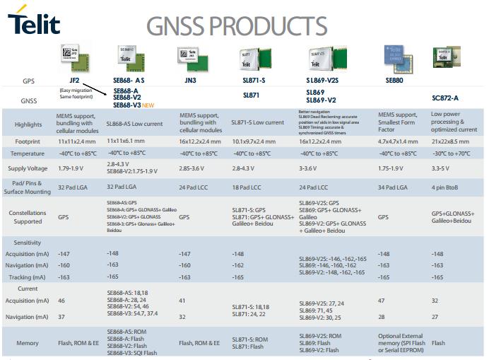
Telit Wireless Solutions offers excellent multi-constellation solutions including the SL869-V3 Jupiter family of modules. The SL869-V3 is Telit's GNSS Unified Form Factor family which allows customers to select among different GNSS technologies. Modules in this family are offered in a 16x12.2 mm, 24-pad, LCC package supporting GPS, Glonass, Galileo, and QZSS constellations.
GPS “Global Positioning System” was the first GNSS system in the United States and originally used for military applications. Today it is commonly used term in agriculture for describing a positioning system that allows us to map fields and auto-steer equipment. The term GPS is specific to the United States' GNSS system, the NAVSTAR Global Positioning System. As of 2013, the United States NAVSTAR Global Positioning System (GPS) and the Russian GLONASS are the only fully operational GNSS, and accordingly account for the bulk of UNAVCO's available equipment and project support.
For GPS designs, Telit offers the SL871LS family of modules. The SL871LS can navigate to -162 dBm and track to -166 dBm, thereby providing improved performance in harsh environments. This advanced GNSS module can track GPS and Glonass or GPS and Beidou constellations simultaneously and it is Galileo ready.
Global coverage for each system is generally achieved by a satellite constellation of 20–30 medium Earth orbit (MEO) satellites spread between several orbital planes. The actual systems vary, but use orbital inclinations of >50° and orbital periods of roughly twelve hours (at an altitude of about 20,000 kilometres or 12,000 miles).