- Home
- Symmetry Blog
- LEO vs MEO vs GEO Satellites
LEO vs MEO vs GEO Satellites
What's the Difference?

About Cobus Heukelman
In the rapidly evolving landscape of satellite communications, understanding the distinctions between Low Earth Orbit (LEO), Medium Earth Orbit (MEO), and Geostationary Earth Orbit (GEO) satellites is essential for selecting the optimal solution for modern applications. From global connectivity to navigation and real-time data transmission–follow along as we uncover advantages and trade-offs of each system to ensure the development of optimal satellite-based systems.
Clarifying GEO vs GSO
The terms GEO and Geosynchronous Orbit (GSO) are often confused with one another, partly because one is a special case of the other. GSO refers to a satellite taking 24 hours to complete an orbit around Earth. To an observer standing still on the Earth’s surface, the GSO satellite will return to the exact same point in the sky after one day. In some geosynchronous orbits, satellites can move either with or against the direction of Earth’s rotation.
GEO is a subset of GSO where the satellite orbits directly above the equator. This causes the satellite to appear stationary from the ground, simplifying ground-based antenna alignment.
Orbital Definitions and Altitudes
Satellites are classified by the altitude and characteristics of their orbits, which directly influence their performance and applications. The table below (Figure 1) outlines the key differences between the three main orbital regimes.
Abbreviation | Orbit Name | Altitude [km] |
LEO | Low Earth Orbit | 160 to 2000 |
MEO | Medium Earth Orbit | 2000 to <35786 |
GSO | Geosynchronous Orbit | 35786 |
GEO | Geostationary Equatorial Orbit | 35786 |
Figure 1: Comparing LEO, MEO, GSO, and GEO orbital definitions and altitudes.
LEO: Low Earth Orbit
LEO and GEO are the two extremes in terms of orbital altitude. LEO satellites are significantly smaller and operate much closer to Earth. The rockets required to launch them are smaller and more cost-effective. However, a major drawback of LEO systems is that many satellites are needed to maintain coverage over a given geographic area.
Since LEO satellites orbit the Earth multiple times per day, each one quickly passes over its coverage zone–requiring another satellite to follow closely behind to maintain continuous communication. This increases network complexity, as many ground stations are needed to communicate with the satellites, and different frequencies must be used to prevent interference between them.
LEO satellites are the most common and widely deployed in modern satellite networks. Their key advantages include lower latency, smaller size, reduced launch costs, and more affordable replacement costs. The largest LEO satellite operator is Starlink, a subsidiary of American aerospace company SpaceX. Since 2019, Starlink has launched thousands of mass-produced small satellites into LEO, accounting for over 60% of all active satellites in orbit. These satellites typically operate at an altitude of around 550 km. LEO systems like Starlink’s are particularly well suited for mobile connectivity and broadband internet services.
Beyond cost and coverage benefits, LEO devices can typically connect to multiple satellites simultaneously from various angles, enhancing the reliability of the communication link. For applications that require global mobile connectivity – such as disaster response, maritime operations, or remote fieldwork – LEO is often the preferred solution. The lower altitude of these satellites significantly reduces signal travel time, resulting in low latency. This is especially important for real-time communication, such as voice calls, where even slight delays can be disruptive. Anyone who has experienced a poor VoIP connection understands how frustrating long pauses or lag can be.
GEO: Geostationary Equatorial Orbit
In contrast to LEO systems, GEO satellites remain fixed in the sky relative to a specific point on Earth, continuously covering the same geographic area. While GEO satellites are larger and more expensive to deploy, they offer the advantage of scalable coverage, enabling network operators to expand service gradually as demand grows.
Since GEO satellites maintain a constant position, ground-based antennas must be precisely aligned to point at them. This setup works well for fixed installations, such as satellite TV dishes mounted on buildings, but is impractical for mobile devices like smartphones, which require dynamic connectivity.
All GEO satellites orbit above the equator, which introduces limitations at higher latitudes. As users move farther north or south–into regions like Canada or Europe–the angle between the satellite and the ground becomes shallower. This makes the signal more vulnerable to interference from obstacles such as tall buildings, trees, or mountains (Figure 2). Despite these challenges, a single GEO satellite can cover up to 42% of the Earth's surface, making it highly efficient for wide-area broadcast and fixed communication services.
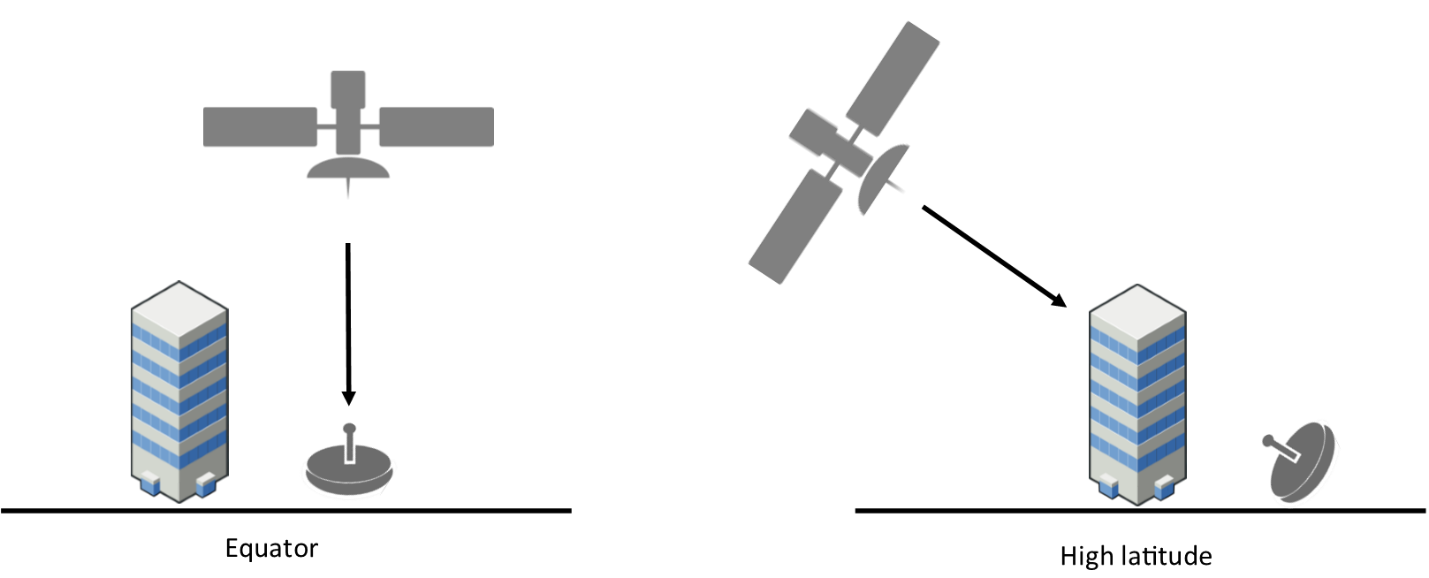
Figure 2: Visual showcasing GEO satellite signal vulnerability from potential interference of obstacles such as tall buildings, trees, or mountains.
MEO: Medium Earth Orbit
You may be wondering–what about MEO satellites? Wouldn’t they offer a balanced compromise between LEO and GEO? In some ways, yes. Like LEO systems, MEO satellites require a constellation to provide continuous geographic coverage. However, they operate at much higher altitudes, typically between 10,000 to 22,000 km.
MEO satellites are most commonly used for global navigation systems such as GPS, GLONASS, and Galileo. For example, GPS satellites orbit at an altitude of approximately 22,000 km, completing one orbit every 12 hours. Compared to Starlink’s LEO satellites at 550 km, reaching MEO requires significantly more fuel and larger launch vehicles. The satellites themselves also need to be more powerful to transmit stronger signals over greater distances, and the increased altitude results in higher communication latency.
These are all important trade-offs to consider when designing a satellite constellation–balancing performance, cost, and coverage requirements.
Satellite-to-Ground Communication
With all the attention on satellites, it’s easy to overlook the importance of ground communication. Ground stations are a crucial link that receive satellite data for processing, analysis, and operational use. As the number of satellites in orbit increases, infrastructure within the ground sector will need to keep pace.
Ground stations are generally either stationary or mobile in their position. They are most commonly located in elevated areas (for a better line of sight), remote locations, coastal locations, and in urban communications centers.
From agriculture to industrial, a broad number of industries depend on reliable satellite-to-ground communication. Some key examples of ground control applications that require effective satellite connectivity include:
Low-latency, high-speed broadband in rural, remote, and underserved areas.
IoT asset tracking such as livestock and soil monitoring, pipeline monitoring, and shipping container monitoring.
Emergency services, like Apple’s SOS feature.
Security and disaster response, including redundant communications during natural disasters.

Ground Communication Solutions at Braemac Americas
At Braemac Americas (rebranded from Symmetry Electronics), we offer a curated portfolio of in-stock solutions for satellite-to-ground communication, including receivers, advanced antennas, and system-in-package solutions. With expert design-phase support, Braemac makes it easier than ever to incorporate these components into your designs.
Maximizing Efficiency with Advanced Antenna Solutions
Receivers are a key component of ground control designs. Responsible for capturing and decoding satellite signal transmission, next-gen GNSS receivers like the AsetRx-U3 from Septentrio can be paired with the following Calian full-band antennas for ultra-accurate location intelligence.


Subscribe
Stay up to date with industry and supplier news!