- Home
- Symmetry Blog
- A Field Trial Utilizing a Soil Monitoring System
From Murata: "A Field Trial Utilizing a Soil Monitoring System to Visualize the Condition of Agricultural Land~Promoting measures against salt damage in the Mekong Delta region in cooperation with Can Tho University, Vietnam~"
About Symmetry Electronics
Established in 1998, Symmetry Electronics, a Division of Braemac, is a global distributor of electronic components and systems. Combining premier components and comprehensive value-added services with an expert in-house engineering team, Symmetry supports engineers in the design, development, and deployment of a broad range of connected technologies.
Exponential Technology Group Member
Acquired by Berkshire Hathaway company TTI, Inc. in 2017, Symmetry Electronics is a proud Exponential Technology Group (XTG) member. A collection of specialty semiconductor distributors and engineering design firms, XTG stands alongside industry leaders TTI Inc., Mouser Electronics, and Sager Electronics. Together, we provide a united global supply chain solution with the shared mission of simplifying engineering, offering affordable technologies, and assisting engineers in accelerating time to market. For more information about XTG, visit www.xponentialgroup.com.
Murata Manufacturing Co., Ltd. (head office: Nagaokakyo-shi, Kyoto; Chairman of the Board and President: Tsuneo Murata) is promoting measures to address salinity impact to agricultural land by conducting field trials utilizing a soil monitoring system that makes it possible to visualize the condition of agricultural land in the Mekong Delta*1 in collaboration with Can Tho University, a national university of Vietnam. The initiative is part of “Studies on Sustainable Soil Uses*2” (hereinafter referred to as “the Project”), based on an agreement between the governments of Japan and Vietnam to provide ODA (Official Development Assistance) in support of measures to address the problem of salinity impact to agricultural land.
1.Background of the Project
Vietnam’s Mekong Delta region is subject to salinity impact from the infiltration of seawater during the dry season as a result of a decline in the volumetric flow rate of the Mekong River and the action of the tides under the impact of climate change driven by global warming. In addition to salt damage, the environment for agriculture has become harsher than in the past due the increasing severity of droughts and floods. The Mekong Delta region contains 30% of Vietnam’s farmland and accounts for the majority of its domestic food production, and the damage, which is estimated to run into billions to tens of billions of yen, has become a serious problem.
Murata has been conducting the Project since 2017 in collaboration with Can Tho University, which possesses deep knowledge of agricultural and environmental research in the Mekong Delta. The Company is using compact sensor units that draw on its know-how and expertise in the fields of electronic components, circuit design and software design to measure the condition of agricultural land and channel water with high precision. Combining these observations with independently developed monitoring tools, we can visualize and analyze the environmental conditions with a view. It contributes to the implementation of IT in agriculture in the Mekong Delta region by preventing salt damage to rice paddies and orchards, ameliorating salt and sulfur contamination of agricultural land and water channels, and creating a mechanism to comprehensively manage fertilizers, crops and irrigation systems.
2.Features of the Soil Monitoring System
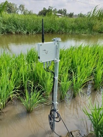
The wireless transmitter-receiver system consists of a gateway, a router and several sensor nodes. Each sensor node is made up of a transmitter*3 and three sensor units to measure the soil, field and channel water quality, and the sensing data is accumulated in the cloud.
The main features are as follows.
- A compact approximately 13cm sensor unit equipped with three sensors for measuring two types of electrical conductivity*4, temperature and moisture content
- High-precision analysis of conditions utilizing a sensor incorporating a uniquely shaped sensor element and a proprietary algorithm
- Over a year of continuous operation on three size AA batteries
- IP68*5 dust and water resistance and reliable rustproofing enabling prolonged use in harsh environments
3.Future Outlook
The Project began with a three-year plan from 2017 utilizing know-how developed in the restoration of agricultural land based on monitoring of the salt content condition of farmland damaged by the tsunami triggered by the Great East Japan Earthquake of 2011. In addition to Soc Trang and Ca Mau Province, where the monitoring system was initially introduced, in October 2018 we deployed the system in other four locations in Ben Tre and Kien Giang province. Through joint researches with many research institutions, Murata will continue to make efforts to realize global SDGs*6 by utilizing its unique sensing and wireless technologies.
4.Installation in the Mekong Delta
 A transmitter communicating with a sensor unit (Ben Tre province, Vietnam)
